
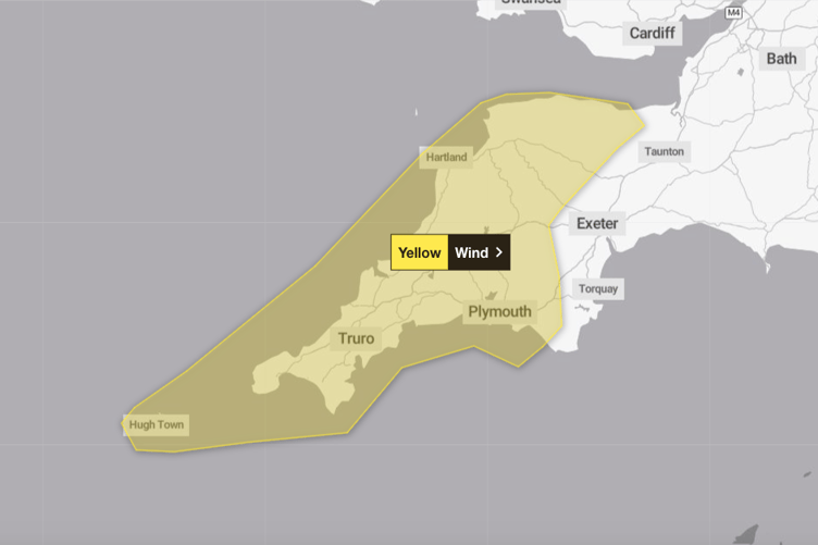
SOUTH Western residents will have to wait a little longer for springtime weather, as the Met Office issue another weather warning.
The yellow warning for wind is set to come into force from 4pm today (April 8), until 6am tomorrow morning (April 9).
The winds come off the back of the country’s most recent named storm, Storm Kathleen.
Dave from Kernow Weather Team explained: “Storm Kathleen moves on, leaving the doors open for another Atlantic weather depression to move in for Monday evening. The weather models have a slight disagreement (more of a falling out) on the final path of this system which could become a named Storm by the French Met Service, due to them seeing a bigger impact than us.


“What we do know at this stage is that this next low pressure is likely to just brush Cornwall on the south coast, and during Monday evening time, the winds will start picking up from a southeasterly direction, backing to a Northwesterly later on. By 10pm, we'll start see gust of wind of 40-50mph widely inland, and as high as 60 to 80+mph along exposed coasts, before easing down on Tuesday afternoon.
“Please take extra care, if you're around our lovely coastline over the next few days.
“We have spring tides and very large waves are predicted. Your life or that of others, are not worth a picture of the big waves. Even from the shore, large breaking waves can sweep you off your feet and out to sea in seconds.
“Take care if walking near cliffs; know your route and keep dogs on a lead. In an emergency, call 999 and ask for the Coastguard.”
Comments
This article has no comments yet. Be the first to leave a comment.