STORM Kathleen is forecast to hit areas of Devon and Cornwall tomorrow (April 6).
This is the eleventh storm to hit the UK since the start of the year and is set to bring very windy weather.
A yellow weather warning has been issued by the Met Office and will be in place from 8am till 10pm.
The Met Office has said that injuries and danger to life from flying debris is possible as well as damage to buildings.


It is possible that road, rail and ferry services may be affected, longer journey times are expected and some roads and bridges may close.
Furthermore, power cuts across the region might take place as well as large waves along the coastline.
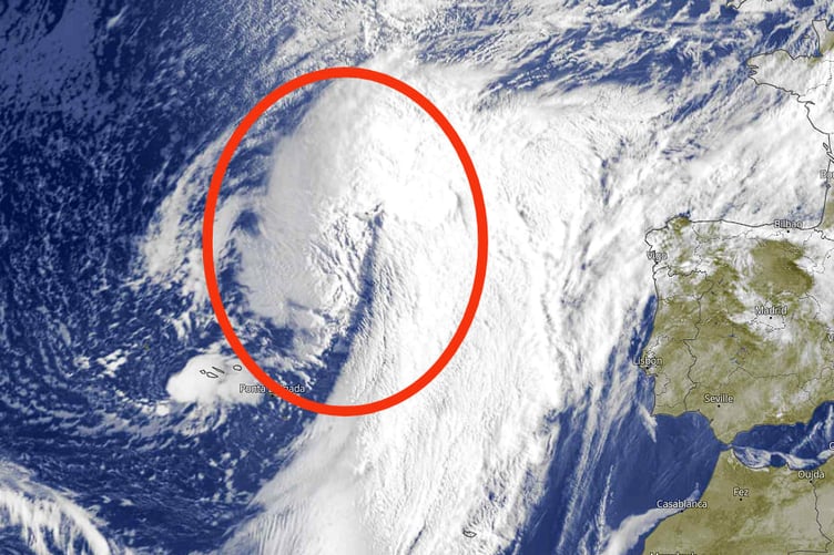
Dave from the Kernow Weather team has explained satellite image of the storm as it develops over the Atlantic.
He said: “Here is the latest Satellite image for Storm Kathleen, which is currently out in the Atlantic as that huge lump of cloud as seen in the image below, and, it is currently undergoing what we call 'explosive cyclogenesis' which is when central pressure of the low system, falls 24 millibars in 24 hours. (It's rapidly developing into a potent storm.)
“Rapid acceleration of air caused by the jet stream, high up in the atmosphere can remove air from the column, reducing its weight, therefore causing pressure to fall at sea level. This in turn sucks in air, which converges from surrounding regions resulting in faster and faster rotation of the circulation, in the same way that ice skaters spin faster by drawing their arms in. The resulting winds peak over a period of a few hours and can be strong enough to bring down trees and cause structural damage.”
Comments
This article has no comments yet. Be the first to leave a comment.